Kat Pèp La (The People’s Map)
Community Intelligence for Neighborhood Regeneration
Location: Turgeau, Port-au-Prince, Haiti
Role: Project Director & Community Intelligence Lead
Status: Research & Pilot Development
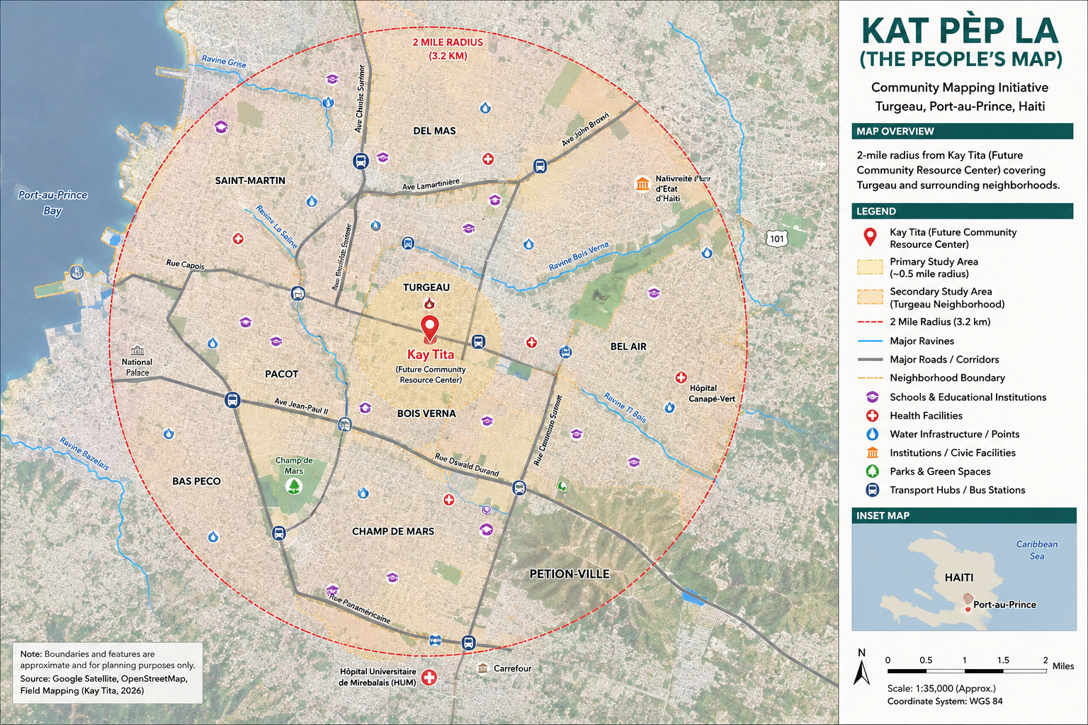
Overview
Kat Pèp La (“The People’s Map”) is a community-led GIS initiative that empowers residents of Turgeau to document their neighborhood, generate trusted spatial data, and shape the future of their community. By combining participatory mapping, geospatial technology, and local knowledge, the project transforms community experience into actionable intelligence that supports equitable planning, climate resilience, and regenerative development.
Centered around the future Kay Tita Community Resource Center, Kat Pèp La begins within a defined study area in Turgeau and creates the foundation for a neighborhood-scale Community Intelligence Platform. Rather than relying solely on external organizations to define local priorities, residents become the primary contributors to understanding their community’s assets, infrastructure, environmental conditions, and investment opportunities.
The long-term vision is to create a replicable model for community-led mapping and neighborhood regeneration that can be adapted across Port-au-Prince and throughout Haiti.
The Challenge
Many neighborhoods in Haiti remain largely invisible within traditional planning systems.
Communities often lack:
Reliable GIS data
Standardized addressing systems
Infrastructure inventories
Environmental assessments
Publicly accessible planning information
This absence of data makes it difficult for residents, governments, researchers, and investors to coordinate meaningful long-term investments. As a result, decisions are frequently reactive rather than informed by a comprehensive understanding of neighborhood conditions.
Kat Pèp La seeks to change that by creating the spatial knowledge needed to support resilient, community-driven development.
Our Approach
Kat Pèp La combines community engagement with modern geospatial technology through four integrated workstreams.
-
Residents are trained to map neighborhood assets, infrastructure, public spaces, environmental conditions, and community resources using participatory GIS methods.
-
Data collected through field research is integrated into an interactive GIS platform featuring dashboards, StoryMaps, spatial analysis, and open data resources that support decision-making.
-
Maps are paired with community narratives to document not only physical infrastructure but also the history, culture, and lived experiences that define Turgeau.
-
The information generated through Kat Pèp La informs future investments in climate resilience, infrastructure, mobility, public space, and the development of Haiti’s first Living Building.
Project Focus Areas
The initiative documents multiple layers of neighborhood information, including:
Community assets
Housing and land use
Streets and pathways
Public facilities
Water and sanitation systems
Energy infrastructure
Environmental risks
Ravines and watershed systems
Schools and institutions
Local businesses
Public gathering spaces
Cultural landmarks
Neighborhood boundaries
Community stories and oral histories
Why It Matters
Port-au-Prince has experienced decades of rapid urban growth without the coordinated planning systems, infrastructure investment, or spatial information needed to guide sustainable development. What was once a capital designed to support a much smaller urban population has evolved into a metropolitan region of more than three million people, placing extraordinary pressure on roads, drainage systems, water networks, sanitation, electricity, housing, and public services. Population growth, rural migration, repeated natural disasters, and prolonged political instability have accelerated urban expansion far beyond the capacity of the city's existing infrastructure and planning systems.
Yet one of the city's greatest challenges is the absence of neighborhood-scale intelligence. Many communities lack reliable geospatial data, standardized addressing systems, infrastructure inventories, environmental assessments, and publicly accessible information that can support planning and investment. Without this foundational knowledge, governments, nonprofits, researchers, and development partners are often forced to make decisions with incomplete information, limiting their ability to coordinate resources, prioritize investments, or measure long-term impact. UN-Habitat has identified fragmented spatial planning and informal urbanization as significant barriers to sustainable development in metropolitan Port-au-Prince.
Turgeau exemplifies both the challenges and the opportunities facing Port-au-Prince. Rich in history, institutions, and community leadership, the neighborhood also faces aging infrastructure, degraded ravine systems, unreliable utilities, and limited planning data. Rather than viewing these conditions solely as problems, Kat Pèp La recognizes them as an opportunity to establish a new foundation for neighborhood regeneration.
By combining participatory GIS, community knowledge, environmental analysis, and spatial storytelling, Kat Pèp La transforms local knowledge into actionable intelligence. Residents become active contributors to documenting their own neighborhood, producing trusted data that can inform infrastructure planning, climate resilience, public investment, emergency preparedness, and community-led development.
My Role
As Project Director & Community Intelligence Lead, I oversee the initiative's strategic vision, partnerships, and technical development.
My responsibilities include:
Designing the Community Intelligence Platform
Developing GIS workflows and spatial data standards
Leading participatory mapping strategy
Building partnerships with academic institutions and technical advisors
Coordinating interdisciplinary research
Integrating ArcGIS, Survey123, StoryMaps, and community-generated data
Translating mapping insights into long-term neighborhood planning
Kat Pèp La reflects my passion for using geospatial technology to empower communities, bringing together data, design, and local knowledge to support more equitable, resilient, and regenerative cities.
Current Partners
Kay Tita
Impact Hub Port-au-Prince
Studio Drum Collective
REGEN Services
Community Leaders and Residents of Turgeau
Academic Research Partners (In Development)
Looking For
Kat Pèp La is actively seeking collaborators who are interested in advancing community-led urban innovation.
We welcome partnerships with:
Universities and research institutions
GIS professionals and geospatial scientists
Urban planners and architects
Environmental and climate resilience experts
Foundations and philanthropic partners
Civic technology organizations
Graduate students and research fellow
“We’re building a multidisciplinary research collaborative to develop one of Haiti’s first community-driven GIS and neighborhood intelligence platforms. If your work intersects with geospatial science, urban planning, participatory research, regenerative design, or civic technology, we’d love to explore how we can work together.”