david zhu-pierre-louis

Tree Inventory & Site Assessment Tool


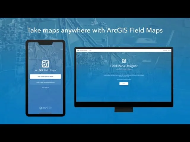
This Field Maps application is designed to support arborists, developers, and surveyors in collecting detailed, location-based tree data directly in the field. It captures key attributes such as species, health, risk level, canopy spread, and recommended action—creating a structured dataset that can be used for site planning and decision-making.

By combining mobile data collection with GIS, the tool enables real-time documentation of tree conditions, helping teams assess which trees should be preserved, pruned, or removed. The result is a more efficient workflow and a clearer understanding of ecological and development constraints on-site.

Download Field Maps and give this a try
Pure Joy Sanctuary

A Regenerative Neighborhood Demonstration Project

Location: Spanaway, Washington

Project Type: Community Planning • Regenerative Development • GIS • Infrastructure Planning • Living Laboratory

Role: Project Director & Community Intelligence Lead


Project Overview

Pure Joy Sanctuary is a 1.25-acre regenerative neighborhood demonstration project located in Spanaway, Washington. More than a residential development, it is an exploration of how neighborhoods can create lasting environmental, social, and economic value by treating housing, ecology, infrastructure, and community as interconnected systems.

The project will transform an existing residential property into a mixed residential neighborhood consisting of an existing home, a detached flex studio, and three thoughtfully designed duplexes connected by shared community spaces, food forests, native landscapes, ecological restoration areas, and outdoor learning environments.

The vision is to demonstrate a replicable model for regenerative neighborhood development that can inspire future communities.


Vision

Pure Joy Sanctuary exists to demonstrate that residential development can create value beyond buildings.

By integrating ecological restoration, Indigenous-informed stewardship, community intelligence, regenerative design, and geospatial technology, the project seeks to become a place where people and nature flourish together.

Our long-term vision is to establish Pure Joy Sanctuary as a Living Laboratory where residents, universities, public agencies, nonprofit organizations, and industry partners collaborate to advance regenerative community development through research, education, and innovation.


Geospatial Strategy

GIS serves as the project's decision-support platform, helping us understand existing conditions, evaluate development options, coordinate infrastructure, and plan for long-term stewardship of the property.

Current applications include:


Regenerative Framework

Pure Joy Sanctuary is organized around six interconnected pillars.

Ecological Regeneration

Protect and restore native ecosystems while improving biodiversity, forest health, wildlife habitat, soil quality, and long-term ecological resilience.

Community

Create places where neighbors naturally connect through shared gardens, gathering spaces, outdoor learning environments, and collaborative stewardship.

Human Well-being

Design healthy environments that encourage walkability, access to nature, social connection, and physical and emotional well-being.

Learning & Innovation

Develop the site as a Living Laboratory supporting research in biodiversity, climate resilience, GIS, food systems, regenerative design, and community health.

Stewardship

Apply Indigenous-informed principles of reciprocity, ecological restoration, and long-term care for the land.

Cultural Connection

Honor the Coast Salish peoples whose ancestral homelands include this landscape while fostering opportunities for partnership, learning, and environmental stewardship.


Our Partners


Collaboration Opportunities

Pure Joy Sanctuary is intentionally being developed as an open demonstration project.

We are actively seeking collaborators interested in advancing regenerative community development through research, planning, technology, and education.

Current partnership opportunities include:

Universities

Applied research, internships, capstone projects, and long-term monitoring.

Public Agencies

Green infrastructure, housing innovation, climate resilience, urban forestry, and GIS.

Technology Partners

GIS, AI, remote sensing, environmental monitoring, digital twins, citizen science, and data visualization.

Design Professionals

Architecture, planning, engineering, ecology, landscape architecture, and Indigenous stewardship.

Foundations & Philanthropy

Support for ecological restoration, research, educational programming, and Living Laboratory development.


Kat Pèp La (The People’s Map)

Community Intelligence for Neighborhood Regeneration

Location: Turgeau, Port-au-Prince, Haiti

Role: Project Director & Community Intelligence Lead

Status: Research & Pilot Development

Overview

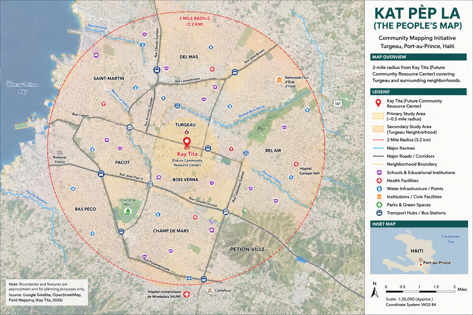
Kat Pèp La (“The People’s Map”) is a community-led GIS initiative that empowers residents of Turgeau to document their neighborhood, generate trusted spatial data, and shape the future of their community. By combining participatory mapping, geospatial technology, and local knowledge, the project transforms community experience into actionable intelligence that supports equitable planning, climate resilience, and regenerative development.

Centered around the future Kay Tita Community Resource Center, Kat Pèp La begins within a defined study area in Turgeau and creates the foundation for a neighborhood-scale Community Intelligence Platform. Rather than relying solely on external organizations to define local priorities, residents become the primary contributors to understanding their community’s assets, infrastructure, environmental conditions, and investment opportunities.

The long-term vision is to create a replicable model for community-led mapping and neighborhood regeneration that can be adapted across Port-au-Prince and throughout Haiti.


 The Challenge

Many neighborhoods in Haiti remain largely invisible within traditional planning systems.

Communities often lack:

  • Reliable GIS data

  • Standardized addressing systems

  • Infrastructure inventories

  • Environmental assessments

  • Publicly accessible planning information

This absence of data makes it difficult for residents, governments, researchers, and investors to coordinate meaningful long-term investments. As a result, decisions are frequently reactive rather than informed by a comprehensive understanding of neighborhood conditions.

Kat Pèp La seeks to change that by creating the spatial knowledge needed to support resilient, community-driven development.


Our Approach

Kat Pèp La combines community engagement with modern geospatial technology through four integrated workstreams.


Project Focus Areas

The initiative documents multiple layers of neighborhood information, including:

  • Community assets

  • Housing and land use

  • Streets and pathways

  • Public facilities

  • Water and sanitation systems

  • Energy infrastructure

  • Environmental risks

  • Ravines and watershed systems

  • Schools and institutions

  • Local businesses

  • Public gathering spaces

  • Cultural landmarks

  • Neighborhood boundaries

  • Community stories and oral histories


Why It Matters

Port-au-Prince has experienced decades of rapid urban growth without the coordinated planning systems, infrastructure investment, or spatial information needed to guide sustainable development. What was once a capital designed to support a much smaller urban population has evolved into a metropolitan region of more than three million people, placing extraordinary pressure on roads, drainage systems, water networks, sanitation, electricity, housing, and public services. Population growth, rural migration, repeated natural disasters, and prolonged political instability have accelerated urban expansion far beyond the capacity of the city's existing infrastructure and planning systems.

Yet one of the city's greatest challenges is the absence of neighborhood-scale intelligence. Many communities lack reliable geospatial data, standardized addressing systems, infrastructure inventories, environmental assessments, and publicly accessible information that can support planning and investment. Without this foundational knowledge, governments, nonprofits, researchers, and development partners are often forced to make decisions with incomplete information, limiting their ability to coordinate resources, prioritize investments, or measure long-term impact. UN-Habitat has identified fragmented spatial planning and informal urbanization as significant barriers to sustainable development in metropolitan Port-au-Prince.

Turgeau exemplifies both the challenges and the opportunities facing Port-au-Prince. Rich in history, institutions, and community leadership, the neighborhood also faces aging infrastructure, degraded ravine systems, unreliable utilities, and limited planning data. Rather than viewing these conditions solely as problems, Kat Pèp La recognizes them as an opportunity to establish a new foundation for neighborhood regeneration.

By combining participatory GIS, community knowledge, environmental analysis, and spatial storytelling, Kat Pèp La transforms local knowledge into actionable intelligence. Residents become active contributors to documenting their own neighborhood, producing trusted data that can inform infrastructure planning, climate resilience, public investment, emergency preparedness, and community-led development.

My Role

As Project Director & Community Intelligence Lead, I oversee the initiative's strategic vision, partnerships, and technical development.

My responsibilities include:

  • Designing the Community Intelligence Platform

  • Developing GIS workflows and spatial data standards

  • Leading participatory mapping strategy

  • Building partnerships with academic institutions and technical advisors

  • Coordinating interdisciplinary research

  • Integrating ArcGIS, Survey123, StoryMaps, and community-generated data

  • Translating mapping insights into long-term neighborhood planning

Kat Pèp La reflects my passion for using geospatial technology to empower communities, bringing together data, design, and local knowledge to support more equitable, resilient, and regenerative cities.


Current Partners

  • Kay Tita

  • Impact Hub Port-au-Prince

  • Studio Drum Collective

  • REGEN Services

  • Community Leaders and Residents of Turgeau

  • Academic Research Partners (In Development)


Looking For

Kat Pèp La is actively seeking collaborators who are interested in advancing community-led urban innovation.

We welcome partnerships with:

  • Universities and research institutions

  • GIS professionals and geospatial scientists

  • Urban planners and architects

  • Environmental and climate resilience experts

  • Foundations and philanthropic partners

  • Civic technology organizations

  • Graduate students and research fellow

We’re building a multidisciplinary research collaborative to develop one of Haiti’s first community-driven GIS and neighborhood intelligence platforms. If your work intersects with geospatial science, urban planning, participatory research, regenerative design, or civic technology, we’d love to explore how we can work together.